Published On Jan 8, 2020
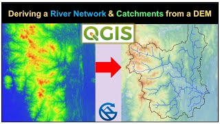
This video demonstrates how to use map algebra for burning a river into a DEM prior to catchment delineation. In this way we force the drainage in a DEM to follow the river. In the presented method the DEM is proportionally lowered in order to preserve the flow direction in the DEM. The method has been described by Wesseling et al. (1997) and developed for PCRaster. Here QGIS is used.
First the river is rasterized. Then a standardized DEM is calculated with values between 0 and 1. Next at river cells the standardized DEM is reduced with 1, resulting in a range from -1 to 0 for those cells. Finally we multiply the standardized DEM with the original DEM to get the values back in the original range, but with the river burned into the grid.
Credits for OpenStreetMap data: © OpenStreetMap contributors
SRTM data available from USGS Earth Explorer: https://earthexplorer.usgs.gov
Reference to the method:
Wesseling, C. G., W. P. A. Van Deursen, and M. De Wit. "Large scale catchment delineation: a case study for the river Rhine basin." Proc. JEC-GI 97 (1997): 16-18.
This video is part of IHE Delft OpenCourseWare. More free resources can be found at http://www.gisopencourseware.org
Subscribe to the YouTube Channel for updates!