Published On Jan 9, 2023
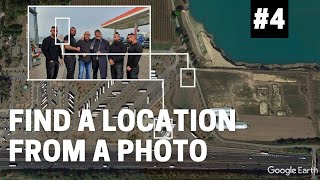
In this session, we look at how to find aerial photos that were taken in and around World War Two timeframes and stitched together on Google Earth. These tiles give full views on Google Earth of what European cities looked like during World War Two, where in many, there are/were clear signs of war.
This tutorial is also a good way to learn how to look at past imagery on Google Earth, as the main tool used is the historical imagery slider. We also cover simple geolocation topics in the tutorial, as well as how to find things on satellite imagery, or in this case, aerial photos.
Be mindful, the only way for you to follow this tutorial and find the old aerial imagery yourself is through Google Earth Pro (desktop): https://www.google.com/earth/about/ve...
If you are following this tutorial, and want to view the old aerial imagery in Google Earth yourself, the most interesting places to view to see what they looked like during World War Two on Google Earth are:
- London
- Berlin
- Warsaw
- Paris
OSINTAtHome Playlist: • OSINT At Home - Tutorials on Digital ...
TOOLS
Google Earth Pro (desktop): https://www.google.com/earth/about/ve...
CREDITS FOR THIS VIDEO
Google Earth satellite imagery
Related websites and social media platforms for the purpose of finding the sites
Music: Tea Time by Ofshane, Rinse Repeat by DivKid
#osint #geolocation #googleearth #googlemaps #worldwartwo #warhistory