Published On Mar 13, 2024
How to Identify Groundwater Potential Zones | Groundwater Identification
Description:
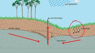
Welcome to Part 1 of our series on Identifying Groundwater Potential Zones using the Analytic Hierarchy Process (AHP) method in ArcMap. In this video, we delve into the crucial aspect of understanding the parameters essential for pinpointing groundwater potential zones accurately.
Groundwater plays a pivotal role in sustaining ecosystems and meeting human needs. However, its availability varies significantly across different regions. Hence, employing effective methodologies like AHP becomes imperative for groundwater resource management.
By comprehensively understanding and integrating these parameters within the AHP framework in ArcMap, we can develop a robust methodology for delineating groundwater potential zones with precision.
Stay tuned for Part 2, where we will demonstrate the practical application of the AHP method in ArcMap for identifying groundwater potential zones. Don't forget to subscribe and hit the notification bell to stay updated with our latest tutorials!
#GroundwaterPotential #AHPMethod #ArcMap #Hydrogeology #GIS #GeospatialAnalysis #WaterResourceManagement #dawnofgeospatialworld
Chapters
00:00 Today's Topic
00:05 Parameters & Methodology
00:30 Intro
00:36 Drainage Density
02:45 Lineament Density
09:35 Slope
10:58 Geology, Geomorphology & LULC
11:33 Vector to Raster
14:17 Outro
Playlists ⬇️
1️⃣ Various Space Agencies & Missions: https://bit.ly/44UBJQI
2️⃣ Data Download Processes for GIS Work: https://bit.ly/44WYP9D
3️⃣ QGIS Basics Tutorials: https://bit.ly/3Oljo95
4️⃣ ArcMap Basics Tutorials: https://bit.ly/3DoAopy
5️⃣ Terrain Analysis: https://bit.ly/44UBJ38
6️⃣ Hydrological Analysis: https://bit.ly/472LGgY
7️⃣ Image Classification: https://bit.ly/3sb1iyR
8️⃣ Indices: https://bit.ly/3RfKPUB
9️⃣ Advanced Methods: https://bit.ly/3NRgt8H
The following geospatial and environmental solutions video instruction is available on this channel:
👨🏻💻 ArcGIS, QGIS (Geospatial Analysis, Monitoring)
🗺️ Cartography
🗺️ Basics of Mapmaking
🛰️ Basics of GIS & Remote Sensing
You can watch our videos on YouTube : @dawnofgeospatialworld
If you think they're useful, kindly subscribe to our channel.
Instagram : / dogw_official
Facebook Group : / 1044628716532282
Thank you So Much.....