Published On Feb 21, 2022
I created the most iconic and difficult loop in the Superstition Wilderness.
Edit: So MoonJuice Hikes recently completed this loop, making it look easy. Check out his video here:
• The Superstition Icon Loop - 3 Day So...
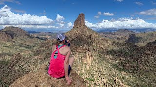
I live in Phoenix, Arizona. the closest true wilderness area is the Superstition Wilderness. This is my back yard. This is my home. I love hiking, and the Superstitions have endless opportunities for adventure. I have been all over the Superstitions.
I'm a big fan of several other Youtube channels. One of those channels is livehardxlovehard. If you haven't checked them out, you should; / livehardxlovehard
Anyway, we were talking and they asked for some recommendations in the Supes. So, in case you aren't familiar with them, Adam and Elise are athletes. They're in phenomenal shape and do some unbelievable hikes. Usually while trail running. So I wanted to put together something for them that was hard. Really hard.
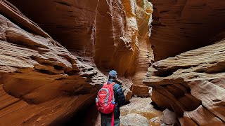
And I came up with a loop that would link together all of my favorite parts of the Superstitions. It would start at the Siphon Draw trailhead. From there, you would climb 2.8 miles and about 2,800 ft of elevation gain to the Flatiron. From the Flatiron, you would continue on the Ridgeline trail another 7ish miles (plus another 1,000 or so elevation gain) to the Carney Springs Trail. Instead of exiting at Carney Springs which is the traditional Superstition Ridgeline route, you would then go off trail up to Robbers Roost, then down to the Fremont Saddle. From there, you would take the Peralta Trail past Weavers Needle and eventually link up at Boulder Canyon Trail. From there, you would again go off trail and head up to Battleship Mountain. Battleship Mountain is probably my favorite hike in the Superstitions, so I couldn't make a loop without it. After the summit, you would return to Boulder Canyon Trail, then take Second Water to First Water to Crosscut, and back to your car. It's about 30 miles and 5~6,000 feet of elevation gain and loss. The intent was that they would do this hike in a single day. (Let that sink in.)
So we talked some about making this happen, but we all have jobs and life responsibilities, so it hasn't come together yet. But the thought of the trail got stuck in my mind. This loop was epic. So why wasn't I doing it? Sure, I couldn't do this in a day, but I'm an avid backpacker. I could do it over a few days.
For the record, I asked Tina if she wanted to go along. It was a hard no from her. But I would do it anyway. So I started planning. And then, a window of opportunity presented itself. And I went for it.
Things did not go well.