Published On Premiered Mar 3, 2024
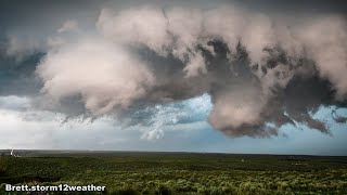
On May 28, 2023, the Storm Prediction Center issued a Slight Risk for much of the Texas Panhandle, mainly focused on large hail and high winds. A lee surface trough persisted east of the Rockies with a weak upper-level shortwave moving in from the southwest. While speed shear was not very impressive, there was decent veering in the wind profiles with surface winds out of the SSE and 500 mb winds out of the WSW. Additionally, an EML lead to steep mid-level lapse rates and CAPE values of up to 2000 J/Kg. In this marginal severe environment, there was enough forcing for isolated supercell development. This was the first of two separate supercells that I chased on this day. While this storm didn't produce any tornadoes, it did develop a few transient wall clouds. Additionally, its nearly stationary movement allowed for excellent viewing without the need to constantly reposition. Later on in the evening, a second supercell would produce several tornadoes near Stratford Texas. That video can be found linked to the end of this one.