Published On Jun 20, 2023
THIS VIDEO IS A RECONSTRUCTION OF THE FOLLOWING SITUATION IN FLIGHT:
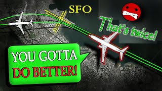
16-JUN-2023. An American Airlines Airbus A321 (A321), registration N584UW, performing flight AAL2133 / AA2133 from Newark Liberty International Airport, NJ (USA) to Phoenix Sky Harbor International Airport, AZ (USA) was on approach to Phoenix but the controller gave them the approach clearance for runway 8 too late. The pilot reported that they were nose to nose with the other traffic, which was on approach for the south runways. The pilot also said that the situation was extremely dangerous. Being on the frequency of the Tower, the pilots reported that they had problems with the Arrival and requested the phone number to call TRACON.
Join me on Patreon: / you_can_see_atc
#realatc #aviation #airtrafficcontrol
_______________
Timestamps:
00:00 Description of situation
00:17 All aircraft are descending towards Phoenix Sky Harbor Airport
02:11 Start of dangerous situation
04:03 “You had us nose to nose with traffic”
04:30 American 2133 contacted Tower and requested phone number to call the TRACON
_______________
THE VALUE OF THIS VIDEO:
THE MAIN VALUE IS EDUCATION. This reconstruction will be useful for actual or future air traffic controllers and pilots, people who plan to connect life with aviation, who like aviation. With help of this video reconstruction you’ll learn how to use radiotelephony rules, Aviation English language and general English language (for people whose native language is not English) in situation in flight, which was shown. THE MAIN REASON I DO THIS IS TO HELP PEOPLE TO UNDERSTAND EVERY EMERGENCY SITUATION, EVERY WORD AND EVERY MOVE OF AIRCRAFT.
SOURCES OF MATERIAL, LICENSES AND PERMISSIONS:
Source of communications – https://www.liveatc.net/ (I have a permission (Letter) for commercial use of radio communications from LiveATC.net).
Map, aerial pictures (License (ODbL) ©OpenStreetMap -https://www.openstreetmap.org/copyrig...) Permission for commercial use, royalty-free use.
Radar screen (In new versions of videos) – Made by author.
Text version of communication – Made by Author.
Video editing - Made by author.
HOW I DO VIDEOS:
1) I monitor media, airspace, looking for any non-standard, emergency and interesting situation.
2) I find communications of ATC unit for the period of time I need.
3) I take only phrases between air traffic controller and selected flight.
4) I find a flight path of selected aircraft.
5) I make an animation (early couple of videos don’t have animation) of flight path and aircraft, where the aircraft goes on his route.
6) When I edit video I put phrases of communications to specific points in video (in tandem with animation).
7) Together with my comments (voice and text) I edit and make a reconstruction of emergency, non-standard and interesting situation in flight.