Shapefile overlay tools: dissolve, union, intersection and merge using QGIS
GeoGIS Labs
400 subscribers
1,826 views
22
About
Share
Published On Feb 28, 2022
In this video, I am going through a few shapefiles overlay tools that you can use on QGIS
#QGIS
show more
Share/Embed
Facebook
Twitter
Pinterest
LinkedIn
Video Link
Up next
5:47
How to load a shapefile into Google Earth using QGIS
GeoGIS Labs
228 views • 2 years ago
11:47
QGIS Geoprocessing Tools & Operators (Dissolve, Clip, Union, Difference, Intersection, etc)
RS & GIS
5.6K views • 1 year ago
17:57
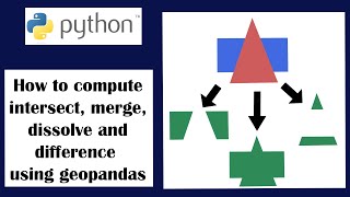
Geopandas: intersection, merge, dissolve and difference between two shapefiles using python
GeoGIS Labs
1.6K views • 1 year ago
12:51
QGIS Part2 - How to extract, merge and clip vector data
TheContour
32K views • 4 years ago
3:48
Dissolve boundaries
ArcGIS
1.6K views • 1 year ago
26:28
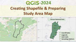
Creating Shapefile and Study Area Map for any Location | Latest Tutorial using QGIS
Researchocrat
62K views • 8 months ago
14:07
QGIS Buffering - Part 1
Q-tips
13K views • 5 years ago
8:00
Overlay analysis gis
Patrick Kennelly
2.7K views • 4 years ago
10:58
(NO Music) QGISBasic #109: Buffer Distance showing in Degrees
Hal Hart
2.6K views • 3 years ago
22:12
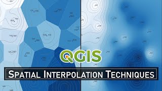
Spatial Interpolation Techniques in QGIS
GeoDelta Labs
27K views • 1 year ago
7:28
How to do Dissolve / Union / Intersect / Merge in Arc GIS (Geo processing)
Gis and Remote Sensing Basics
51K views • 4 years ago
5:08
How to Use the Difference Tool in QGIS | GIS Vector Overlay Tools
Surveying Solutions
1K views • 10 months ago
11:19
Overlapping Shapefile Tutoral
Aaron Moriak
5K views • 3 years ago
15:57
How to overlay a raster on a basemap using python - Part 1
GeoGIS Labs
323 views • 7 months ago
18:52
Calculating the area of a polygon shapefile using python
GeoGIS Labs
2.9K views • 2 years ago
7:53
How to Split and Merge Polygon in QGIS
Terra Spatial
28K views • 2 years ago
6:26
How to Validate & Fix Geometry in QGIS
GIS Coordinated
13K views • 2 years ago
12:55
14 - QGIS Tutorial - Fixing Messy Boundaries Using Difference
Fool's Workshop
3.3K views • 3 years ago
23:56
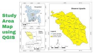
Study area Map using QGIS
GIS & RS Solution
116K views • 3 years ago
14:06
How to convert a latitude and longitude coordinate points in a CSV into a shapefile using python
GeoGIS Labs
1.3K views • 2 years ago
Show More