Published On Feb 7, 2021
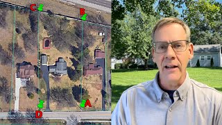
Overlaying images on Google earth is a helpful way to get an idea of how things might relate and or look in a more real-world spatial way.
This video shows the use of a survey image that is overlaid. But the accuracy is in no way considered survey grade.
This was to give me an idea before going out to assess the easement work for the first time and give the client an estimate to do the work.
Before the work gets done, the client or I would get a surveyor to mark out any portion that was not 100% known to avoid damaging other people's property.
show more