Published On Jul 8, 2021
Located within the Yuba Watershed, Nevada County is between Sacramento and Lake Tahoe.
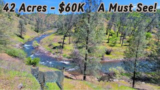
Explore Deer Creek's history and geography from the air and water. With Cessna fly-over, drone, satellite, ground, and underwater footage, you'll follow the watershed from its headwaters near Skillman Horse Camp to Scotts Flat Reservoir, over spectacular waterfalls, and Lake Wildwood to the Black Swan Preserve where Deer Creek flows into the Yuba River.
The film follows slickens debris into Marysville where the conflict between mountaineers and farmers established far-reaching property use laws. Along the entire 34-mile journey, you'll see vignettes of the plants and animals that live there.
Toxic mining legacy issues, as well as harmful algal blooms and steps for practicing healthy watershed awareness, are included.
Visit the website at followingdeercreek.com for a plant and animal list, as they appeared in the film, and their related articles. Print-outs of text in the video are also available.
The film and plethora of linked resource materials are a resource for Nevada County nature and history teachers as well as for anyone leading educational groups.