Published On Sep 21, 2024
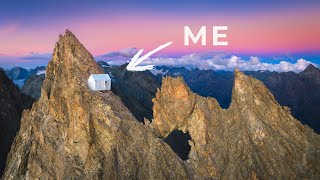
The section of the Tour du Mont Blanc (TMB) from Le Peuty to La Tête aux Vents is one of the most scenic and rewarding parts of the trail. It takes you through beautiful alpine landscapes with spectacular views of the Mont Blanc massif, glaciers, and valleys. This part is typically completed over 1-2 days depending on your pace and camping preferences.
Overview
Starting Point: Le Peuty (near Trient, Switzerland)
Ending Point: La Tête aux Vents (France)
Distance: Approximately 14-16 km (9-10 miles)
Elevation Gain: ~1,000 m (3,280 feet)
Difficulty: Moderate to challenging, with significant elevation gain and a few steep ascents.
Time: 6-8 hours, depending on fitness level and breaks.
Detailed Route Breakdown
Le Peuty to Col de Balme
Distance: 5.5 km (3.4 miles)
Elevation Gain: 800 m (2,624 feet)
Time: 2.5 - 3 hours
From Le Peuty, you will ascend towards Col de Balme (2,191 m), which forms the border between Switzerland and France. This section of the trail involves a steady climb but is not technically difficult.
Highlights: As you approach the Col, the views of the Mont Blanc massif become more dramatic. The sight of Mont Blanc from the Col is breathtaking, especially on a clear day.
Col de Balme to Refuge Albert 1er
Optional Detour: If you want to extend your hike and explore, you can take a short detour to Refuge Albert 1er. The refuge sits below the Tour Glacier and offers fantastic views.
Time for Detour: 1-2 hours round-trip (depending on pace and breaks).
Col de Balme to Aiguilette des Posettes
Distance: 5 km (3.1 miles)
Elevation Gain: Minimal (slight descent and ascent)
Time: 1.5 - 2 hours
After reaching Col de Balme, the trail follows a ridge that leads towards Aiguillette des Posettes (2,201 m). This section of the hike offers sweeping views of the Chamonix Valley and the surrounding peaks.
The ascent is gradual but can be challenging due to the rugged terrain and exposure in some sections.
Aiguillette des Posettes to La Tête aux Vents
Distance: 4-5 km (2.5-3 miles)
Time: 2 hours
From Aiguillette des Posettes, the trail descends through alpine meadows and forests towards La Tête aux Vents (2,130 m).
The views towards the Mont Blanc range and the Chamonix Valley are stunning, making this a great place to stop for a break or lunch.
Camping Options
Le Peuty (Start Point)
Camping du Peuty: Basic campsite with toilets and water. Ideal for starting your hike fresh in the morning.
Col de Balme (High Altitude Wild Camping)
It's possible to wild camp at or near the Col de Balme, though the area is exposed and windy. Be sure to follow local regulations regarding wild camping.
Aiguilette des Posettes (Wild Camping)
Another potential wild camping spot. This area offers great views but is also quite exposed.
La Tête aux Vents (End Point)
Refuge La Flégère: If you continue past La Tête aux Vents, you can find accommodation or set up camp near the Refuge La Flégère, though there is no official campsite here.
What to Expect
Terrain: Steep ascents, rocky paths, alpine meadows, and ridgelines. Proper footwear is essential.
Water: Bring plenty of water. You can refill at refuges or streams but treat the water before drinking.
Weather: Be prepared for changing weather. Conditions can shift rapidly in the mountains, and it may get windy or cold, even in summer.
Navigation: The trail is well-marked, but having a map or GPS is recommended.
This is a classic section of the Tour du Mont Blanc, combining alpine beauty with physical challenge. Be prepared for a long, rewarding hike!