Published On Mar 5, 2020
LuciadRIA is the answer to today's demands for powerful, lightweight applications in the browser. Driven by today’s most advanced web technologies, LuciadRIA uses WebGL, HTML5, and JavaScript to deliver desktop-like performance to your web applications.
With LuciadRIA, you can expect high performance and complete accuracy, with desktop-like visualization of satellite and other imagery, vector-based data, and dynamic content, such as tracks. Connect to your data via OGC web services or drag and drop common file formats. Data can be explored in a 2D or 3D map view or vertical intersection view. Combine with a timeline view for 4D analysis.
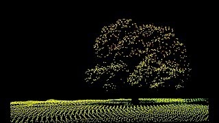
A Point Cloud is a 3D model made up of thousands – or even millions – of georeferenced points and hence gives an incredibly detailed representation of reality. Point clouds are typically created through 3D laser scanning techniques such as Light Detection and Ranging (LiDAR) technologies, although they can also be extracted from imagery using photogrammetric methods. Each point has its XYZ coordinates and some attributes. These attributes can represent time, flight line, intensity (how much light returns back from a point), color, classification, RGB value, etc.
Point clouds also have numerous additional functionalities. Loading point clouds in Luciad gives you access to the full range of Luciad’s visualization and analysis options: view the point clouds in full 3D, seamlessly integrate the points with other data sets, such as aerial imagery and terrain data, to visualize the entire environment. You can also use expressions to style and filter the data, or measure and compare, and so on.
A photo sphere is a 360º (horizontal) and 180º (vertical) spherical panoramic imagery. By combining photo spheres and point clouds in Luciad, users can have an immersive experience navigating through their geographic information system (GIS) data sets. Various use cases which are beneficial to the daily operations of various enterprises such as utility companies and local authorities. Think of it as Google Street View on steroids!