Published On May 19, 2023
Intro: 00:44
Steps trail out: 01:48
Steps trail back: 06:33
The Steps: 4:55
Alternate line: 10:51
Steps trail pictures: 11:59
*7-4-23 Southern low water approach trail IS RIDABLE with the exception of approximately 60 yards. Use adjacent slickrock as alternate.*
Steps trail is part of the Dells or the Granite Dells system of trails. More specifically the Willow Dells Trails. The Granite Dells consists of three Dells areas; The Constellation Trails, The Willow Dells, and the Lakeshore/Storm trails. Prior to the Constellation and Lakeshore/Storm trails, when you said the “Dells” it was the Willow Dells area.
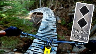
Steps trail can be daunting at first sight. Daunting because of the namesake steps feature. There are man-made railroad tie-like wooden steps at the bottom, natural loose rock steps at the top, with a tree thrown in at the middle. Another highlight of this trail is a very steep slickrock slab with a great view of Willow Lake and the Willow Creek dams down below. Low Water trail at East Bay can be used as a bypass to this slickrock feature. Steps is rated black or difficult. The south end has a short and steep mini chute/hairpin section that ends at East Bay. Steps trail is accessed by the Willow Loop trail at the north, and by East Bay Loop at the south. Closest access to Steps is from the south. There is free parking on the north side of Willow Lake Rd: 1900 Willow Lake Rd, (34.595889, -112.435667). However, during the wet month’s some or all of the southern Willow Lake Road low water approach trail will be submerged/muddy. Because of this it is typically best to ride Steps trail from June to early December. Alternate access is from the north at the Willow Loop trail intersection. Hiker traffic is typically light to moderate. I included one alternate line video and many still pictures at the end. To get an idea of the slope of this trail, see the still pics at the end.
As with all my trail videos, it is my intent to first document and character ride each trail as mapped the best I can. It’s no different here at the Willow Dells. With these videos I’m not saying these are the best lines, the worst lines, or the only lines. Just the lines that were on the mapped trail or just off it for the most part. My rule of thumb was if a line was with the flow/direction of the mapped trail I went for it. I will likely do an alternate line video sometime in the future.
Have a great ride. -- goMTB prescottAZ.
Season Rode/Recorded: FALL
Please see my channel's "About" page for the intent of this channel. / @gomtbprescottaz9685
Companion trail map used: • Companion trail map used Mountain Bik...
My playlist(s): / @gomtbprescottaz9685
Steps trail Coordinates Out: 34.600232, -112.429122
https://duckduckgo.com/?q=34.600232%2...
Steps Trail Coordinates Back: 34.603883, -112.430173
https://duckduckgo.com/?q=34.603883%2...