Published On May 6, 2021
This tutorial will show how to do the land use Zoning with GIS data. It's possible to do the land use mapping without a physical survey, These are the processes.
Step-1: How to download data from geoportal
In this tutorial, we used a geoportal called 'Geo Fabric'.
https://www.geofabrik.de/
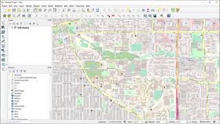
Step-2: Import the data to QGIS
Step-3: How to draw the Site Perimeter /Import Site Perimeter
From our previous video, u can see how to draw a site perimeter.
• 1 How to draw any shape in QGIS with...
Step-4: Select the working Layer/s
There are several layers when u are importing data from the geo portal. U have to keep your necessary layer and have to delete other.
Step-5: Clip the Selected Area from layer/s
By clipping, we will keep the data only related to our projects. From the geoportal, we will get a lot of data which may be so bigger for a small computer. So it's better to get rid of unnecessary data.
Step-6: Categorize Each Layer
We will categorize selected layers. Each layer has its own attributes. Some attributes go to private, some to public or semi-public. So we need to check and identify whether the attributes are public/semipublic or private.
Step-7: Extract & Merge the Similar Elements
We will select the same type of attributes. Extract them as separate layer
Step-8: Draw the Polygons